 |
|
|
Education program |
||||||||||||||||||||||||||||||
|
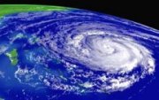
page 1 ~ The 'Cyclone' - a revolving tropical storm ~ A tropical revolving storm is an intense vortex of air swirling in the atmosphere named "Cyclone, Hurricane or Typhoon" with very strong winds circulating around it in an anti-clockwise direction in the Northern Hemisphere and in a clockwise direction in the Southern Hemisphere. What needs to be clearly understood by seafarers is that the swirling mass of wind is not rotating like the spokes of a wheel travelling at a fixed distance from the centre, for the swirling moisture laden energy mass of air and waves are at all times moving in a 'curving' motion towards the lower pressure 'eye' of the Cyclone. The nearer it is to the eye the higher the waves generated and the faster the wind becomes, and it accelerates to known speeds of up to 300 km/hour. Note: You must never ever head your vessel in the direction of the cyclone 'body,' for once you are 'running' with the wind or waves you will be unable to turn your vessel into wind without danger of 'broaching' and you will be 'forced' towards the centre and, as you get nearer the 'eye' the waves will become so steep as to thrust your vessel under. At all times your vessel must be heading away from the eye or anchored facing the waves using a Para anchor to hold it stationary as you wait 'safely' for the Cyclone to move away. If you are in its path and cannot 'beach' your craft or find safe haven then prepare to meet your ancestors as you 'pray' that it will change its direction..
Northern hemisphere revolving tropical storm of immense power. Index
The purpose of this document is to bring a little understanding to those who are not 'hardened' seamen with years of exposure to violent storm situations or cyclonic weather. It is written as a simple introduction to some weather processes that could affect offshore voyagers, and it is given here to assist you with a little mental preparation that could help you when offshore and bad weather is experienced. I have spent many years fishing at sea in the equatorial regions between the equator and 5 degrees South on the East coast of Africa, and thus have never been exposed to cyclonic conditions that mainly occur in higher latitudes than 5 degrees. (5 to 30 degrees north or south of the equator) The information that follows is purely my own deduction as I sit in seclusion far from the sea drawing upon my 72 years of various experiences. It varies in some aspects of what has been written by others, and thus it is necessary for you to look deeply at what is said so that you understand the situation clearly, for there could be terrifying and disastrous consequences for the unwary. My intent is to give a clear and concise 'pre-meditated' course of action for any sea voyager to take if they find themselves unfortunate enough to encounter a cyclone that 'catches' them unawares. It is very easy to make decisions when one is on secure ground, but once the sea becomes rough and decisions need to be made quickly it can become quite confusing to some who become 'mentally' disturbed by indecisive thoughts that lead to irrational decisions being made. Much is written on cyclones that gives readers the 'impression' that certain 'sectors' or semicircles are navigable, and I know that this is false teaching, as in my opinion one needs to understand that whatever 'sector' one may 'enter' into is very dangerous, and the nearer one is driven by wind and waves towards the centre, the greater the windy 'tempest' and wave heights and greater the danger of injury, drowning and loss of vessel. The only 'reason' why one 'quadrant' becomes more dangerous than others is when the cyclone is moving over the sea surface, thus any vessel that is 'ahead' of the Cyclone is one that is on a 'quicker' collision course with the 'eye,' and the time for avoidance is lessened and all the dangers increase dramatically. In the foreknowledge that a cyclone can change direction at any time and even halt and 'reverse' backwards, one will also then realise that a 'quadrant' or 'semicircle' with an apparent less danger may suddenly become a very dangerous one. Intensifying wind speed and lowering barometric pressure may be an indication of this. I trust that the information and images provided will give the reader a little 'comfort' in the knowledge that they will be more prepared for an eventuality that may never arise. For those of you that are 'beginner' ocean voyagers it would be practical to obtain a copy of the "Times Atlas and encyclopaedia of the sea" published by 'Times books of London,' that gives a lot of pertinent information on waves and ocean currents and danger zones at the different times of the year. Weather Pressure systems In a High pressure system the air is moving outwards from its centre, and it flows towards any Low pressure system situated outside its perimeter. The air flow at the centre is zero speed and calm weather prevails and the 'standard' barometric 1013 mb. It goes 'high' when it rises above the standard pressure and may rise to 1030 or more mb. The air mass of a High pressure system South of the Equator revolves in an anti-clockwise direction, and in the northern hemisphere it revolves in a clockwise direction. Between the High and the Low systems there is a 'ridge' of faster moving air formed as one system pushes up against the other, and this has the effect of accelerating the wind speed of the air mass between the High and Low systems. This 'frontal' ridge of air can be the cause of very rough weather but it is not 'cyclonic' in that it is not moving in a circular motion as is the cyclone characteristic. Some vessels use this fast moving wind in order to make good speed in their journey, however if it is blowing from the direction in which one seeks to travel then it is a very uncomfortable hindrance, and it may be safer to not try and 'bash' ones way through it but to simply make use of the Para-anchor that will hold you steady as the front passes by and you do not 'lose ground.' In a Low pressure system that air is flowing inwards towards its centre, and as it moves closer to its 'vortex' the wind speed accelerates. Prior to becoming a tropical Cyclone there are three indicators as to the category of a Low.
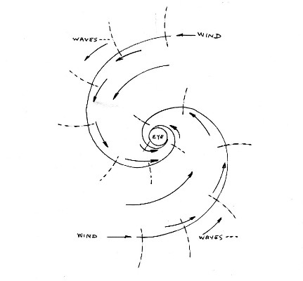
Once the wind speed increases above 35 kts then the revolving mass begins to form into a Category 1 Cyclone with winds in the order of 35 to 50 kts. As time passes the barometric pressure drops lower and the winds increase their speed. It may take up to 3 days or more for a ''Depression' to deepen and become a Cyclone. In a large Cyclone there may be a barometric drop to 920 mb or less, and the lower it drops is an indication of the pressure difference between the High and the Low, and the lower the mb reading the greater the pressure difference and faster the wind speed becomes. The air mass is rising upwards from the centre of the vortex like an invisible tornado, and the circular wave movement drives floating objects towards its centre, and the nearer the centre the higher the wind speed and more dangerous the waves. Even though a 'calm' of negligible wind is experienced by those on land as the centre of the 'eye' of the cyclone passes overhead, this is NOT the case on the sea, for on the ocean the Cyclone 'core' is a deadly mass of very confused and breaking waves that approach the vessel from every direction once the eye has been 'entered' and, all Cyclones are extremely dangerous and, any direction taken having a 'following' sea is deadly as all the waves are travelling towards the 'eye' in a 'roundabout' way and driving the vessel inwards and into greater danger and higher wind speeds. Try and also understand that the outer 'edge' of the 'eye' is in fact the point where the wind is revolving around the perimeter of the eye in a completely circular motion at the fastest intensity and highest and steepest wave heights, and in a category 4/5 Cyclone with wind speeds of 300 km/hr this means a speed of 5 km/per minute or 80 metres a second or 250' a second, and I do not believe that any vessel being driven by the wind and waves in this category situation would survive because, the vessel would be driven under the sea by the fury of breaking waves totally engulfing them. The sea area containing the revolving Cyclone can be as much as 600,000 square miles or more, and all this 'mass' of stored energy is moving like a 'Tornado' that spins at an ever increasing speed at its vortex. The eye of the 'storm' has to accommodate the mass volume of the energy being compressed into a very small area and to do this the speed of the wind becomes 'insanely' powerful and in complete 'control' over any material 'body' that ventures too close. The cyclone mass usually moves or 'travels' between 200 and 400 nm in a day. Note: All wind and waves moving within the outer perimeter of the tropical storm subtends in an arc towards the perimeter of the 'eye,' and all vessels within the entire mass are drawn 'inexorably' towards the 'eye' and, any vessels within the extreme danger quadrant are in grave peril because the 'eye' of the storm is moving 'upwind' towards them, compacting and magnifying waves ahead of it and also 'halving' the 'meeting' time. Any vessel approaching the eye from any direction always end up in the extreme danger quadrant if they survive to that point. Northern hemisphere simplified sketch showing subtending arc of wind and waves towards the eye of the storm.
North of the Equator the cyclone air mass revolves in an anti-clockwise direction. Baric wind Law The Baric Wind Law is an indicator that assists one in determining in what direction a cyclone 'core' is situated in relation to the vessel at sea. This may seem unnecessary today when there are satellite images and radio weather updates, but not all ocean travellers have these aids, and thus the basic understanding of and use of a barometer and the Baric Law can give you added assurance when offshore. For only when you know that you are in the 'safe' and trailing or 'rear' quadrants are you able to safely deploy your sea anchor to hold you steady. For if you are in the 'frontal' quadrant and you deploy the Para-anchor then you could become a 'sitting duck' that is anchored directly in the path of the approaching cyclone and you will most likely meet your maker. This document is to give you an idea as to how to check your position in relation to the cyclone as well as to its direction, and in which direction your vessel needs to travel to get away from the path of the cyclone. If you have a radio or other land or satellite communication then you are in the fortunate position of being able to hear that a cyclone is or has formed and where it is situated and what its direction of movement is. Thus you can 'plot' your direction of travel to move out of its path. The Baric Wind Law states that < If one stands in the southern hemisphere with one's back to the wind, low pressure is on one's right and high pressure on one's left. - - - If one stands in the northern hemisphere with one's back to the wind, low pressure is on one's left and high pressure on one's right. > One of the first factors to consider is the position of your vessel in relation to the equator when you become aware of the deepening Low. For if the Low is between you and the equator and it becomes a cyclone, as it gathers strength it will be moving Southwest towards you in the southern hemisphere and Northwest towards you in the northern hemisphere. As Cyclones revolve in opposite directions in the north and south hemispheres it is best to only study the one aspect relevant to you in the following pages 4, 5 and 6,7 in any detail, this will ensure that you do not remember the information pertaining to the wrong hemisphere in which you are voyaging in.
~ The southern hemisphere Cyclone
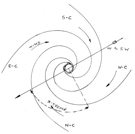
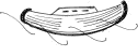
~ The tropical revolving storm is a very Low pressure system (L) known as a "Cyclone" and by other names. In the southern hemisphere (South of the equator) it usually occurs during the months of November to May. In this hemisphere it revolves in a clockwise direction. It forms over the sea between 5 to 20 degrees south of the equatorial belt and may commence as a stationary revolving Low pressure system before it becomes a category 1 Cyclone or greater and begins to move over the water. Once it begins to move, the direction is generally West or WSW approximate headings of 250 to 270 degree - after some days it may ' tend' to alter direction more to the South in a SW to South direction or ANY direction at a speed over the ground of between 5 -15 knots approx. Note: - In order to be moving away from the eye of a Southern Hemisphere Cyclone your vessel must always have the wind and waves on the 'Port' bow and, if you are unable to remain 'heading' slightly into wind due to the power of the waves then it is likely that you are still being driven inwards or 'around' towards the 'eye' even in a fully 'beam' sea apparently heading away from it. In this 'case' if the direction of the eye is moving away from or 'parallel' to your position then it is safer to deploy a Para anchor that will hold you stationary into wind and waves as the Cyclone moves away. Note: - In this sketch below the arrow denotes that the Cyclone is travelling approx SW, and as the most dangerous quadrant is always the one 'ahead' and to the Left of its track in the southern hemisphere, it follows that if it was tracking in a Northerly direction that the most dangerous quadrant would become the NW quadrant. One can 'spin' the image around so that the arrow faces the direction the Cyclone is moving. The equator is to the North of your vessel - here
South of the Equator when a vessel
is facing into the wind at its outer perimeter, the cyclone lies to the 'left' (Port
side) abaft the beam at approx 135 degree to the vessel
direction.
Note ; there are 'variables' to the given headings dependent upon the actual direction of the Cyclone track. It is incumbent for the reader to understand the 'graphics' and my reasoning so that they can come to their own personally informed decision with the 'track' factors that vary from hour to hour. Just REMEMBER that any heading taken that is 'running' with the wind and waves leads you into the eye and its destructive maelstrom of giant waves colliding from every direction from which none can survive in a high category Cyclone. Note the waves drive one in a curving motion always 'tending' inwards towards the eye. In reference to the above image and Cyclone 'track' example demonstration;
E-C vessel position means : Cyclone to the East,
head 315 degrees Note; there are 'variables' to the given headings dependent upon the actual direction of the Cyclone track. Important note: If your vessel is somewhere in the above image within the Cyclonic wind zone influence on any vector from the centre and you face a compass into the wind and waves and take a 'reading' of the compass bearing and, - - - then an hour or more later you do the same thing then, - - - You will know whether you are being drawn closer to its centre or whether you are moving further away because, - - - the wind and waves are curving inwards towards the Cyclone centre and the wind and waves are altering their magnetic heading. This is because the closer you get to the 'eye' of the Cyclone the greater becomes the magnetic bearing and, - - - the further away from the centre you travel the less becomes the magnetic bearing. This 'fact' is taking place all the way from the outer fringes and up to the eye itself. Example - If you enter the outer edge of the mass at N-C with the cyclone to the north of you the wind direction would be from the ESE at approx 120 degrees. If you were 'running' with the waves or being dragged around by them for a few hours you would be situated somewhere between N-C and E-C, and if you took a bearing into the wind and waves it could be 140 degrees, an increase in the magnetic bearing that shows you are in greater danger. This only applies to vessels in the southern hemisphere. It also follows that if you were running with wind and waves towards the 'eye' that your compass heading would be increasing all the way. In fact if you were drawn into its eye your vessel would have travelled a complete circle or more and gone through the entire 360 degrees of the compass before reaching the centre of the cyclone. (Veering to 'Starboard' all the way with a lowering barometric pressure.) It also follows that if any any stage you find that the wind direction is from a 'lesser' magnetic compass bearing, then you are moving away from the eye or, the cyclone is moving away from you. This paragraph only applies to vessels in the southern hemisphere.
Factors to consider
especially if there is no radio
contact to ascertain position of Cyclone. Cyclone to the West of you W-C If you are in the southern hemisphere and you notice the cloud to the West of you and the wind and waves coming from the North, then you would be wise to begin to move East (Compass heading 090 degrees until you are certain that the cyclone 'threat' or danger has abated.) Note; there are 'variables' to the given headings dependent upon the actual direction of the Cyclone track. Cyclone to the East of you E-C If you are in the southern hemisphere and you notice the cloud to the East of you and the wind and waves coming from the South, then you would be wise to begin to move Northwest. (Compass heading 315 degrees until you are certain that the cyclone 'threat' or danger has abated and you keep monitoring its direction.) Note; there are 'variables' to the given headings dependent upon the actual direction of the Cyclone track. Cyclone to the South of you S-C If you are in the southern hemisphere and you notice the cloud to the South of you and the wind and waves coming from the Southwest, then if you are between the equator and Latitude 5 degrees South you may continue in any direction between 270 and 090 degrees, only move South of that line once the cyclone has moved away and the barometric pressure is rising. If you are between Latitude 5 degrees South to 20 degrees South and you notice the cloud to the South of you and the wind and waves coming from the West to Southwest, then you should move in a North to Northeast direction until the barometer is either not falling or is rising steadily. (Compass heading 025 degrees until you are certain that the cyclone 'threat' or danger has abated.) Note; there are 'variables' to the given headings dependent upon the actual direction of the Cyclone track. Cyclone to the North of you N-C
If you
are in the southern hemisphere
and you notice the cloud to the North
of you and the wind and waves coming from the Northeast to East, then you
would be wise to begin to move SE. (Compass heading 135 degrees until you are certain that the cyclone 'threat'
or danger has abated.) The extreme danger of the (dangerous) quadrant is that not only is the wind and wave action driving you in its direction, but the eye is also moving towards you over the sea and the combined speed of these two 'activities' lessens the time for evasion and the danger is quadrupled for slow moving vessels. If you are in the southern hemisphere halfway between N-C and E-C and you notice the cloud to the Northeast of you (Most dangerous position) and the wind and waves coming from the East to Southeast, then you would be wise to consider moving West northwest as you run with the wind on your 'Port' bow crossing the path of the Cyclone and swing around to the North of the Cyclone path. (Compass heading 280 degrees or more and increasing as you swing around to the North until you are certain that the cyclone 'threat' or danger has abated.) Note; there are 'variables' to the given headings dependent upon the actual direction of the Cyclone track. In the southern hemisphere swinging across the path of the Cyclone as you are driven northwards may also be beneficial if it is 'tending' to change direction to the South. Note - 1 : The Compass heading 135 degrees given above (NC) is the 'ideal' general one for when wind and waves permit, but depending on your position reference to your distance from the Cyclone centre and your vessel 'power,' the existing wind and wave influence may prohibit the direction given. In this case you have 2 options. 1 - To bear off to the Starboard (right) keeping the wind and waves on your Port bow as close as possible as you head away from the Cyclone centre that will be behind you on your Starboard (right) rear quarter. If your vessel is slow you may find that you are still losing ground and forced towards the eye. (And it is moving in your general direction) This you will know if the barometric pressure keeps dropping and the situation worsens. In this case you have option 2 left. 2 - In this case you need to hold your ground and halt your movement towards the eye. This you do by deploying your 'Para' anchor. * As long as you are not directly in the path of the Cyclone you will be held steady facing wind and waves and after a time the wind and waves will abate. Note: Para anchor * - The Para anchor can be deployed at any time that you feel the vessel is in danger of being overwhelmed by rough seas or being driven relentlessly towards the eye and also, it can be deployed if you believe that you are outside the path of the Cyclone and you wish to sit safely at anchor until its fury depletes. This decision is yours and must be considered with the understanding that once deployed, it will become irretrievable until the winds have dropped and that you will be a 'sitting duck' if the Cyclone changes course towards you. (Sea conditions may also be a prime factor) Vessels situated to the rear of the moving 'eye' are equally 'battered' by wind and wave action but the mass of the Cyclone is moving away from their position when using a Para and, - - - one needs to understand that there is never any 'guarantee' that a slow moving vessel will escape if it is 'trapped' by high winds and dangerous seas as many an 'ancestral' spirit would testify.
~ The northern hemisphere
Hurricane
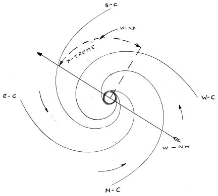
~ The tropical revolving storm is a very Low pressure system (L) known as a : "cyclone or hurricane or typhoon" and by other names. In the northern hemisphere (North of the equator) it usually occurs during the months of May to November. In this hemisphere it revolves in an anti-clockwise direction. It forms over the sea between 5 to 20 degrees north of the equatorial belt and may commence as a stationary revolving Low pressure system before it becomes a category 1 Hurricane or greater and begins to move over the water. Once it begins to move, the direction is generally West or WNW approximate headings of 270 to 290 degree - after some days it may ' tend' to alter direction more to the North in a NW to North direction or ANY direction at a speed over the ground of between 5 -15 knots approx. Note: - In order to be moving away from the eye of a Northern Hemisphere Cyclone your vessel must always have the wind and waves on the 'Starboard' bow and, if you are unable to remain 'heading' slightly into wind due to the power of the waves then it is likely that you are still being driven inwards or 'around' towards the 'eye' even in a fully 'beam' sea apparently heading away from it. In this 'case' if the direction of the eye is moving away from or 'parallel' to your position then it is safer to deploy a Para anchor that will hold you stationary into wind and waves as the Cyclone moves away. Note: - In this sketch below the arrow denotes that the Hurricane is travelling approx NNW, and as the most dangerous quadrant is always the one 'ahead' and to the Right of its track in the Northern hemisphere, it follows that if it was tracking in a Southerly direction that the most dangerous quadrant would become the SW quadrant. One can 'spin' the image around so that the arrow faces the direction the Hurricane is moving.
The equator is to the South of your vessel - here
South of the Equator when a vessel
is facing into the wind at its outer perimeter, the cyclone lies to the 'right' (Starboard side)
abaft the beam at approx 135 degree to the vessel direction. North of the Equator when vessel is facing into the wind the cyclone lies It is incumbent for the reader to understand the 'graphics' and my reasoning so that they can come to their own personally informed decision with the 'track' factors that vary from hour to hour. Just REMEMBER that any heading taken that is 'running' with the wind and waves leads you into the eye and its destructive maelstrom of giant waves colliding from every direction from which none can survive in a high category Cyclone. Note the waves drive one in a curving motion always 'tending' inwards towards the eye. In reference to the above image and Hurricane 'track' example demonstration;
E-C vessel position means : Cyclone to the East,
head 225 degrees Note; there are 'variables' to the given headings dependent upon the actual direction of the Cyclone track. Important note: If your vessel is somewhere in the above image within the Cyclonic wind zone influence on any vector from the centre and you face a compass into the wind and waves and take a 'reading' of the compass bearing and, - - - then an hour or more later you do the same thing then, - - - You will know whether you are being drawn closer to its centre or whether you are moving further away because, - - the wind and waves are curving inwards towards the Cyclone centre and the wind and waves are altering their magnetic heading. This is because the closer you get to the 'eye' of the Cyclone the lesser becomes the magnetic bearing and, - - - the further away from the centre you travel the greater becomes the magnetic bearing. This 'fact' is taking place all the way from the outer fringes and up to the eye itself. Example - If you enter the outer edge of the mass at N-C with the cyclone to the north of you the wind direction would be from the SW at approx 240 degrees. If you were 'running' with the waves or being dragged around by them for a few hours you would be situated somewhere between N-C and W-C, and if you took a bearing into the wind and waves it could be 220 degrees, an decrease in the magnetic bearing that shows you are in greater danger. This only applies to vessels in the northern hemisphere. It also follows that if you were running with wind and waves towards the 'eye' that your compass heading would be decreasing all the way. In fact if you were drawn into its eye your vessel would have travelled a complete circle or more and gone through the entire 360 degrees of the compass before reaching the centre of the cyclone. (Backing to 'Port' all the way with a lowering barometric pressure.) It also follows that if at any stage you find that the wind direction is from a 'greater' magnetic compass bearing, then you are moving away from the eye or, the cyclone is moving away from you. This paragraph only applies to vessels in the northern hemisphere.
Factors to consider
especially if there is no radio
contact to ascertain position of Cyclone. Cyclone to the West of you W-C If you are in the northern hemisphere and you notice the cloud to the West of you and the wind and waves coming from the South, then you would be wise to begin to move East. (Compass heading 090 degrees until you are certain that the cyclone 'threat' or danger has abated.) Note; there are 'variables' to the given headings dependent upon the actual direction of the Cyclone track. Cyclone to the East of you E-C If you are in the northern hemisphere and you notice the cloud to the East of you and the wind and waves coming from the North, then you would be wise to begin to move Southwest. (Compass heading 225 degrees until you are certain that the cyclone 'threat' or danger has abated and you keep monitoring its direction.) Note; there are 'variables' to the given headings dependent upon the actual direction of the Cyclone track. Cyclone to the North of you N-C If you are in the northern hemisphere and you notice the cloud to the North of you and the wind and waves coming from the Northwest, then if you are between the equator and Latitude 5 degrees North you may continue in any direction between 090 to 270 degrees, only move North of that line once the cyclone has moved away and the barometric pressure is rising. If you are between Latitude 5 degrees North to 20 degrees North and you notice the cloud to the North of you and the wind and waves coming from the North to Northwest, then you should move in a South to Southeast direction until the barometer is either not falling or is rising steadily. (Compass heading 155 degrees until you are certain that the cyclone 'threat' or danger has abated.) Note; there are 'variables' to the given headings dependent upon the actual direction of the Cyclone track. Cyclone to the South of you S-C If you are in the northern hemisphere and you notice the cloud to the South of you and the wind and waves coming from Southeast to East, then you would be wise to begin to move ENE to East. (Compass heading 070 to 090 degrees until you are certain that the cyclone 'threat' or danger has abated. Refer to the 'Note - 1' at page end) The extreme danger of the (Dangerous) quadrant is that not only is the wind and wave action driving you in its direction, but the eye is also moving towards you over the sea and the combined speed of these two 'activities' lessens the time for evasion and the danger is quadrupled for slow moving vessels. If you are in the northern hemisphere halfway between S-C and E-C and you notice the cloud to the Southeast of you (Most dangerous position) and the wind and waves coming from East to Northeast, then you would be wise to consider moving South southwest as you run with the wind on your 'Starboard' bow crossing the path of the Cyclone and swing around to the South of the Cyclone path. (Compass heading 315 degrees or less and decreasing as you swing around to the South until you are certain that the cyclone 'threat' or danger has abated.) Note; there are 'variables' to the given headings dependent upon the actual direction of the Cyclone track. In the northern hemisphere swinging across the path of the Cyclone as you are driven southwards may also be beneficial if it is 'tending' to change direction to the North. Note - 1 : The Compass heading 90 degrees given above (W-C) is the 'ideal' general one for when wind and waves permit, but depending on your position reference to your distance from the Cyclone centre and your vessel 'power,' the existing wind and wave influence may prohibit the direction given. In this case you have 2 options. 1 - To bear off to the Port (left) keeping the wind and waves on your starboard bow as close as possible as you head away from the Cyclone centre that will be behind you on your Port (left) rear quarter. If your vessel is slow you may find that you are still losing ground and forced towards the eye. (And it is moving in your general direction) This you will know if the barometric pressure keeps dropping and the situation worsens. In this case you have option 2 left. 2 - In this case you need to hold your ground and halt your movement towards the eye. This you do by deploying your 'Para' anchor. * As long as you are not directly in the path of the Cyclone you will be held steady facing wind and waves and after a time the wind and waves will abate. Note: Para anchor * - The Para anchor can be deployed at any time that you feel the vessel is in danger of being overwhelmed by rough seas or being driven relentlessly towards the eye and also, it can be deployed if you believe that you are outside the path of the Cyclone and you wish to sit safely at anchor until its fury depletes. This decision is yours and must be considered with the understanding that once deployed, it will become irretrievable until the winds have dropped and that you will be a 'sitting duck' if the Cyclone changes course towards you. (Sea conditions may also be a prime factor) Vessels situated to the rear of the moving 'eye' are equally 'battered' by wind and wave action but the mass of the Cyclone is moving away from their position when using a Para and, - - - one needs to understand that there is never any 'guarantee' that a slow moving vessel or ANY vessel will escape if it is 'trapped' by high winds and dangerous seas as many an 'ancestral' spirit would testify. The power and fury of the wind and sea in a big Cyclone will overpower 'all comers' that venture into its 'fold,' and thrust them towards its vortex more easily than the current near the 'rim' of the 'Victoria' falls would drag a canoeist inexorably over the brink and into the 'abyss' of destruction if they venture too near. Note: Vessels that travel at less than 10 kts are at far greater 'risk' than those with speed range of 12 to 20 kts that can more easily 'outrun' a Cyclone.
~ Cyclone
categories ~
The Central pacific hurricane centre gives tables with higher wind speeds listed in each category. The classifications are intended primarily for use in gauging the likely damage and flooding a hurricane will cause upon landfall. Either way you can expect high seas with a water table surge of up to 5 metres or more. Saffir-Simpson Cyclone Scale
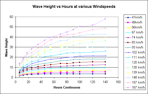
Note: Cyclones generally tend to travel in a westerly direction but are known to alter course in any direction. The speed over the ground of the entire 'system' is usually in the order of 3 to 12 kts. Thus it has the capacity to 'outrun' and destroy slow vessels that have entered into dangerous wind and sea conditions and are unfortunate enough to be in its path or forced around towards and into its 'eye' vortex. Irrespective of which ' quarter' or sector of the cyclone you find yourself you are in extreme danger, for the wind tends to 'drive' your vessel towards the 'eye' and as you get nearer, - - - The fury of the wind and waves become terrifying and wave heights can exceed a height of 60 feet, and the winds increase their speed and waves become more destructive and, - - - Note: On land the 'eye' of the cyclone is still and there is no 'turbulence' and this factor misleads many into thinking that the same applies in the ocean, it does NOT. The power of the energy stored by the moving waves continues to drive the waves towards the cyclone centre even though there is zero wind, and as the energy driving the waves meets itself within the 'eye' there is a a mass of confusion and over falls and total 'chaos.' At the perimeter of the 'eye' of the revolving storm there is a mass of very confused waves that erupt from every side and they will probably overwhelm your vessel if you or your vessel have been 'lucky' enough to have survived that far. You cannot 'run' with the wind and waves and be safe in the 'eye' of a Cyclone, as the wind and waves all lead to its destructive centre. The mass of the cyclone may extend from an approximate diameter of 100 to 800 nm across, and its central circular eye may be anything from 5 to 80 nm wide. The eye is characterised by light winds and clear skies and very turbulent 'chaotic' waves. The barometric pressure at the 'edge' may be 1010 mb, and in the eye it may be as low as 890 mb or less. Thus if the total cyclone width is 250 nm with an approximate distance of 120 nm from outer edge to 'eye,' the drop in barometric pressure of approximately 60 mb that is graded faster at the eye is still an 'average' decrease of 1 mb every 2 nm closer to the eye you get. Halving this barometric 'drop' when on the outer edge to 1 mb every 4 nm still gives one a drop in pressure of 2 mb in 8 nm. Any amount of drop in pressure or increase in pressure is a good indicator as to whether you are losing ground, gaining ground, or stationary in relation to the cyclone. Remember, even if you and it are both stationary in relation to each other and the cyclone starts increasing its size, its central pressure is dropping and so is the pressure around you. This would be more 'common' when it is newly forming and you are already in the middle of it the 'Low.' In this case where there is no wind and no swell yet formed but a 'fast' lowering of pressure then, - - - if you are North of the equator head towards the Southeast. If you are South of the Equator head Northeast so as to move away from the developing 'core' of the 'Low.' If you do not have a radio and weather report, then you are reliant of your barometer and other 'signs' to warn you of the 'arrival' of a Low pressure system. Not every 'Low' pressure system develops into a Cyclone, however in the summer months one needs to be alert. In the winter months the high latitudes of 35 to 60 degrees can develop very large Low pressure systems that are accompanied by gale force conditions of 40 kts and higher, if you are at the leading edge of one of these in the southern ocean then you can be forced southwards, and by using a Para anchor you can stay stationary until its central Low has passed your position of Longitude and the trailing edge helps you East or North. The opposite effect takes place in the northern hemisphere. ~ Wind and wave graph ~ This graph is a 'time' indicator that shows that waves grow bigger over time. Thus it is important to take evasive action and vacate the Low pressure area as soon as possible if you are travelling through tropical waters during the Cyclone season and become aware that one is forming. Example; 90 kts wind raises wave to 14 feet height in 7 hours, and this increases to 25' after 20 hours, and by 100 hours they have grown to 50.' As you can see, if you enter a category 3 - 5 cyclone then you survival chance becomes very slim.
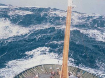
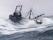
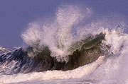
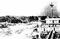
~ Atmospheric Pressure & the
Barometer ~
mm Hg (mercury at 0OC) = 760.0
ATM atmospheres = 1 Barometers record the rise or fall in the atmospheric pressure, thus they are good indicators as to the present pressure that indicates whether one is within a falling or rising pressure air mass. the barometric range is usually between 800 mb (hPa) to 1050 mb (hPa.) ~ Big wave images ~ These pictures are not 'cyclone' related as I simply found them on line, but they do give one and idea as to the intense power of wind driven waves, and they also give you an indication of survivability or otherwise. What you also need to realise is that even though you may be in a strong vessel, - - - if it is thrown around or knocked down then you could suffer severe injury that would hasten your demise. If you are in a small vessel it is important to ensure that you deploy a Para anchor prior to yourself or your vessel becoming endangered. Its deployment is not a guarantee of survival, but it is so if the conditions permit survival. In the past ten years 200 tankers and super tankers have been 'lost' due to wave action as have a multitude of smaller craft. The major 'factor' that kills air pilots is instability in their mind, for their thoughts drive them into attempting to fly to a destination when the weather is less than their capacity to fly. Once airborne and conditions worsen, instead of turning back their thoughts keep 'driving' them on into situations where they become lost or disorientated and they fly into mountains or they enter a 'spiral' dive into oblivion. The danger on the sea is far greater, because one is travelling much slower and full evasive action may take many hours of weariness and danger. Be aware of the fact that every person has a different capacity to handle difficult situations. The the first thing you need to do is to educate yourself fully on all aspects of your intended journey on the sea in the foreknowledge that your life is in your own hands, (and God's) so once you have done your best then leave the rest to God and calmly accept any adverse eventuality.
Giant 'rogue' wave rearing up - Bay of Biscay
|